Roads
The village is laid out in a north-east to south-west direction along the line of a road and straggles it for about a mile and a half, at one time with Stockton Hall at one end and the Old Rectory/Station at the other. Pre 1817 (enclosure ?) it was the main road between York and Scarborough and ran part of the way over a Roman road, traces of which still remain, and ended in a great common at the east end, which swept west and south around its arable fields. Post 1817 the far end of the village ended at a T junction the road to the right going to Warthill, and the one to the left towards the new Scarborough road (now A64) and Strensall. The main street is wide, a throwback to the days before roads were surfaced to give ample opportunity for carts to avoid the ruts in the mud created by vehicles which had passed before. Near the blacksmiths there was also a pond at the side of the road, which enabled carters to water their horses. The pond remains although now much changed as a feature ornamental pond with obligatory fountain set back from the road in a front garden.
Footpaths
The footpath through the churchyard leads direct to Brockfield Hall, and the footpath near where Swann's Garage/Blacksmiths used to be, Carr Bank Lane (erroneously known as Blacksmiths Lane), used to go direct to Warthill, and halfway down that lane there is another path off to the right which comes out half way down Holtby Lane. There used to be footbridges there, but as development took place they were taken out. It is believed that 'Carr' in this instance may have meant a narrow lane for riders on horseback, but its more common explanation was a pool, a fen, or wet boggy lands.
To the side of Stockton Grange is Beanlands Lane which heads off towards Holtby and links with a path to Murton.
On the other side of the road opposite the Methodist Chapel is Sowray's Trot named after Sowray who lived in the ajoining property. Not known when this became a pathway or its original destination, although it was probably Huntington, as it now terminates on the A64 opposite a side road turning which leads to this part of York.
Roman Times and before
While there is evidence in East Yorkshire of Mesolithic activity, insignificant wanderers following game with temporary or seasonal camps, 8 millennium BC, followed by Neolithic and bronze and iron age settlements there is no evidence of any such settlements in Stockton.
The village lies on a geological boundary, which runs from the NE to the SW caused by glacial action at the end of the ice age. A current theory is that prehistoric man used these naturally formed ridges as their dirt track pathways across the country, and centuries later many Roman Roads were built over these tracks. Flint from the Wolds has been found at Fulford as flakes, worked coves and well finished implements. This could have been the first commodity to regularly pass through Stockton on a recognisable highway.
The pattern of roads converging on York is an ancient one, the Boroughbridge, Tadcaster, Stamford Bridge, and Beverley roads all leave the city on the line of Roman predecessors. Only the road to Malton has been realigned in modern times to replace that following the line of the Roman road through Stockton-on-the-Forest. Parts of the road have been found, including a villa at Musley Bank, 1½ mile from Malton, pottery works at Crambeck, east of village of Crambe, at Rycroft Grange, at Stockton and 2 miles north of the village at Sandburn.
The Malton road left the fortress at York, on the site of Minster, and ran directly NE starting a little west of the present Monk Bar. The course is soon taken up by Heworth Green and Stockton Lane, which are closely aligned with the Minster. After a slight turn north on Sugar Hill just beyond the suburbs the present road runs straight and somewhat raised, by up to 2 metres in places, to Stockton. Where the road bends at one or two points there are hedgerows that continue the line. The straight road ends about a mile beyond Stockton and while it lines up with the finds around the Malton end no definite trace has been found further on in the parish. The road was 9 metres wide made of gravel surfaced by a layer of cobbles and flanked by ditches 3 metres wide and 0.9 metres deep. It was widened to 12.9 metres by filling the north side ditch with sand and gravel and surfacing this with cobbles. A new ditch 1.5 metres wide and 1.5 metres deep dug along side the widened road. It was widened again to 15.6 metres by filling in south ditch as before, possibly after 300AD as part of costal defences
The Stamford Bridge road left the south-east gate of York a Roman road followed the course of the present road along a ridge of ground rising above the moors and curving round to Stamford Bridge. Parish boundaries follow the road almost continuously to Gate Helmsley, and then a parish boundary runs close alongside it to the river Derwent. In 1736 vestiges of the old road remained here and there. Warburton's map of 1720 (not seen) shows by broken lines a Roman road turning northwards on the west side of the Derwent near Stamford Bridge, and passing by Whitewell to the east side of Castle Howard. There seems to be no trace of it now. On the east side of the Derwent a Roman road is supposed to have turned northwards about a mile and a half from Stamford Bridge, following the course of Hook Street to Gally Gap, and continuing on to join the road which has already been traced northwards from the Humber, on the high ground to the north of Thornthorpe. Thence in two and a half miles Malton is reached, an undoubted Roman station on the north bank of the Derwent.
Road
making destroyed parts of the forest that need to be cleared to make
way for them. The land provided good pasture and was suitable for
growing crops, like wheat and some barley and oats, plus clay for
pottery. The Romans used to hunt wolf, deer, wild boar and fox in the
adjoining forest. Much of the land to the south east of York was
subject to flooding on a level similar to the great flood of 1625 but
while it may have affected areas as north as Stamford Bridge it is not
thought to have reached Stockton.
When the Romans left in AD410 their roads remained quite serviceable and locals would have been able to utilize these ancient routes for many centuries. However the maintenance of the roads was neglected and eventually they fell into various levels of disrepair. As a consequence travellers had to circumnavigate these hazards.
Between 625 -867 England became united under one king, and trade began to increase using parts of the Roman roads, ancient track ways and new paths. A number were being opened out from and around York, one called the Mickle or Great ran from Stockton, forded the Foss, continued through the chief suburb south of the roman fortress to the Ouse and on to Tadcaster
1066 Plus
The principal methods of using the roads were:
- On foot, carrying personal possessions and minor loads.
- Packhorses, in pack trains were able to carry considerable loads in panniers paired across the horses backs.
- Astride horse back, the fastest mode for many years to come. Weaker persons were carried in litters suspended between two horses.
- Sledges, wheeled carts and slow ox waggons.
- A hammock waggon, available in the 11th century for the elderly.
- Coaches, which appeared in the 14th century, a wherlicate, canvas covered, was used by ladies and invalids, but many ladies preferred to ride sidesaddle rather than in an unsprung waggon.
Food and other goods were carried on pack animals, although carts were available. in fact, probably at least 70 per cent of goods travelling on the roads before the 19th Century were carried in packs. Oxen were too slow and packmen, ponies and donkeys provided the answer. The loads of up to 4cwts, were carried in panniers across the back. A string of pack-horses, between 4 and 40 in number, and usually not more than 14 hands high, would normally all be of the same breed, jack-asses, Welsh cobs, and the ponies of the drove roads of the North of England, sure-footed and hardy. Most packhorses would have been indifferent specimens, running loose and not tethered to each other, their extra freedom making them less liable to stumble on rough terrain. The herd instinct of the horse was sufficient to keep them all together in large numbers, led by an old mare, though small strings probably required tighter control.
The cost of carriage remained constant for three centuries, at a penny per mile for one ton of grain, and double for heavy goods like lead and tiles.
The
earth roads appear to have been adequate until the 16th century
although out in the country only the villages had responsibility for
road repair. This at best they fulfilled by ploughing back the ridges
into the ruts.
1500s
Monastries did some work on roads and bridges but in 1530, Henry VIII closed the monastries and took the lands and buildings without making any provision for the maintenance of the roads.
The
first statute was the Statute of Bridges in 1531 requiring repairs
locally, or by the Justices of the Peace in the county.
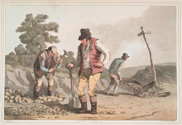
The Highways Act of 1555 made every inhabitant obliged to perform 4 (6 from 1563) days unpaid labour each year on the parish roads, or provide someone in their stead. Those with horses or oxen with carts were bound to lend them for work on the roads.
Annually a Surveyor of Highways, directed parishioners to repair roads for 4 days a year (6 days from 1563). This work was statute labour. The surveyor when elected, unpaid, took over the accounts, examined the roads and bridges, and organized the annual week of repairs. Such presentment had advantages in road repair, since it was a way around the poor results of the former statute labour. It made more money but it did not guarantee a better standard of road. The surveyor had an arduous year in office (and hoped that someone would take over).
The arrangement of the Act looked good on paper, and it must have served some purpose to be renewed every 7 years until 1586 when it was made permanent. There were, of course, exceptions for doctors and clergy and the gentry wriggled out. However, the surveyors were never chosen for their knowledge of road mending and were unpopular. The law stayed in force in one way or another until 1835.
John Leland's Itinerary:
Travels in Tudor England says "My three mile journey from York
to Stockton yn the moore took me across low lying pasture and
wasteland. The next five miles crossed similar terrain......."
1600s-1700s
In 1638 it was still the responsibility of individuals or Parishes to maintain roads and bridges but it does seem that the roads around Stockton were not good and suffered from a lack of maintainance.
At the Quarter sessions in Thirske on 14 April 1607 it was reported the heighway leading from the Citty of York to Stockton and so to Malton via Moncke Bridge was in a great decaie.
At the Quarter sessions in Helmsley on 8 January 1612 a charge was made against the inhabitants of the Wapentake of Bulmer for not repairing Stockton Layne. (Stockton Lane was then the road from York to and through Stockton)
At the Quarter sessions in Thirske on 18 April 1650 a charge was made against the inhabitants of Stockton for not repairing the cawsey leading to Heworth Lane
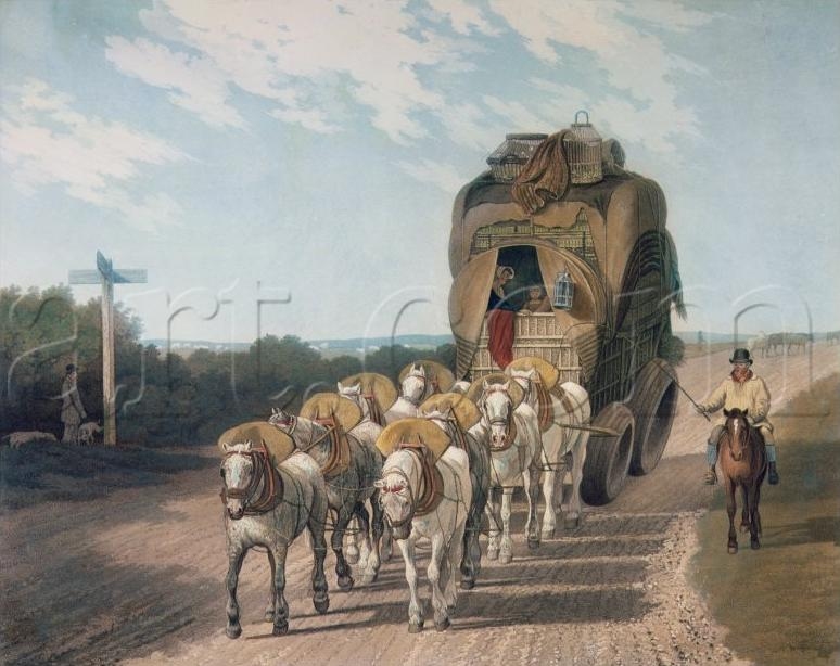
Towards the end of the packhorse era, much greater use of wheeled vehicles, severely eroded the earth surfaces of roads and made them even worse. In the Summer of course, the dust ground up by the heavy coned waggon wheels, caused not only the roads but also the surrounding hedges to turn white. These larger road waggons could have a gross weight of up to 10 tons, all unsprung; they struck uneven surfaces with a shattering jolt, for the road, the waggon and the six or eight horse teams. As a result of the change in transporting methods the first turnpikes began under a general act of 1663,
Turnpikes and Roads
In the 18th and 19th centuries, individual turnpike trusts in England were created through local initiatives. Adjoining trusts coordinated their activities and in some cases shared trustees, so that the roads formed a network and new routes were developed simultaneously. However, these arrangements were generally on a county scale and there was no direction by central government. In many cases, county boundaries defined the limit of responsibility for an individual trust and CountyJustices exercised their duties alongside the local trustees. Hence, it is reasonable to consider English turnpikes on a county basis, though recognising that they grew into a national highway network on which the mercantile, economic and political strength of London exercised a strong influence.
The influence of London-bound traffic is evident in the dates at which turnpikes were created. Counties such as Berkshire, Hertfordshire and Buckinghamshire had several turnpikes covering the radial roads from London by the 1730s, whereas no roads in the remote counties in the Southwest and parts of Northern of England were turnpiked until after the 1750s. The majority of turnpike trusts took responsibility for linear sections of the existing main highway passing through a string of parishes between key market towns. This was especially the pattern in the counties around London where travel was principally along a few well established corridors such as the old Post Roads. However, in counties more than 100 miles distant from the capital, an alternative structure became common. In the west ofEngland turnpike trusts took responsibility for all the commonly used roads running into large cities such as Exeter, Bath and Bristol. This mirrors earlier attempts to finance maintenance of roads that converged on a large market, such as the Oxford Mileways Act in 1567, through which remote parishes were obliged to aid repairs to the last mile of highway entering the city. The urban centred turnpike trusts controlled and maintained much greater distances out along the web of surrounding roads leading from smaller communities. Some radial roads were only a few miles long, terminating in small villages and only connected to the network through the urban hub. Even relatively small market towns in the west, such as Chard, Taunton, Sherborne and Shaftesbury favoured urban-centred trusts, even though major, long-distance highways passed through the centre. It must be remembered that only a small fraction of the mileage of road through a parish was normally turnpiked; the bulk of the local roads remained the responsibility of the parish, repaired by Statute Labour or local taxation. Only the main highways, carrying travellers through the parish, were normally turnpiked.
The different pattern of turnpike development may reflect the way tolls fell on the various communities. Around London most travellers were paying tolls on roads that were well outside their local sphere of influence. The tolls were levied on outsiders who where wearing down the main roads though a parish, which got no benefit from this traffic. In remote areas, a smaller proportion of traffic would be on long distance journey and more of those paying tolls would be from local parishes. Complaints made to the Exeter Trust may be typical in claiming that we in remote Parish A are paying a toll to go into the city, but get no help with maintenance of our parish road, whereas roads in Parish B, midway into the City get help its not fair, please include our small bit of road in the maintenance programme. Such appeals would come from within the county community and be made between gentlemen who would know each other. Hence, the trusts were under more pressure to maintain minor radial roads often at a disproportionate administrative cost compared to the benefit of easier carriage of goods to market.
Differences in the topology, access to competing water-borne transport, sources of wealth in the area and proximity to the homes and resorts of the rich made for significant differences in the pattern of turnpike development in particular counties. The rapid rise in manufacture in the towns of Northern England led to the creation of many totally new routes in the 19th century, whereas in southern counties highways to markets were well established and improvements to existing routes were more likely. One large exception to this pattern was the Holyhead Road, a bold political statement related to the governing of Ireland and almost unique as a government backed initiative. Coach traffic in particular was likely to bring new business to intermediate towns and some trusts tried to make improvements that would attract traffic through there town. Success in persuading the Mail to use the road would be expected to increase overall traffic, bringing more wealth to the inns and those supplying these hostelries with food, provender and services.
The steep decline in long-distance road travel due to the arrival of railways followed a similar pattern to the original diffusion of road turnpiking, but at a much faster pace. The pressures that finally led to the closure of turnpike trusts were national, expressed through Acts of Parliament that brought large clutches of trusts to an end with no regard to county. Hence, in most counties the years in which turnpike closure occurred was similar, a prelude to the eventual creation of County Councils and a true county based organisation of roads.The Turnpike Roads
Creating
a network of well-maintained roads was one of the major achievements of
18th century
However,
the turnpikes were only one phase in the development of a comprehensive
road network in
What Were Turnpikes?
A turnpike is literally a defensive frame of pikes that can be turned to allow passage of horses, but in this context it refers to a gate set across the road to stop carts until a toll was paid. Empowering trustees to erect turnpike gates was the most successful mechanism for ensuring that the costs of improvement and maintenance of a road was financed by the beneficiaries. During the first seven decades of the 18th century a comprehensive network of turnpike roads was created across ritain. These linked the major centres of population by highways which were, in principle, reliably financed and operated for the benefit of long distance commercial traffic, rather than to satisfy the limited needs within individual parishes. Although the turnpikes receive much attention, only one sixth of English roads were turnpiked (Hartmann 1927). The majority of the roads and lanes remained the responsibility of the parish and were toll-free. These were repaired solely by Statute Labour until the General Highways Act of 1835. Enclosure of the old open fields during the 18th century created new, often straight, local roads and rationalised the more chaotic, ancient patterns.
What did they achieve?
The turnpike trusts first stopped the rapid deterioration in the condition of main roads and slowly began to build a network of well maintained highways that allowed road transport to move more efficiently and reliably. The money raised by mortgaging the future toll income permitted substantial investment in the improvement of the drainage, gradients, width and running surface of existing highways. Later it allowed the trusts to build new sections of road to by-pass bad sections and to construct new engineered structures such as embankments, cuttings and even bridges to provide faster routes where horse power could be used more efficiently to haul vehicles. Better roads led to better vehicles which horses pulled more efficiently and at much faster speeds. Although heavy goods were still carried more efficiently by water, road transport became the best means of carrying goods and people rapidly and safely between the booming towns of late 18th and early 19th century England
The End of the Turnpikes
Many turnpike trusts were wound up under General Acts of Parliament between 1873 and 1878. The transfer of resources and sale of assets to repay loans were supervised by the Local Government Board which acted as arbiter in the case of disputes. Toll-houses were sold, gates torn down and responsibility for the main roads passed to Highway Boards. Bond-holders were paid off with any residual funds, though some did not get a satisfactory return on their investment. For instance investors in the Harwell to Streatley Turnpike Trust were repaid less than a half of their capital and bondholders received less than a fifth of the face value of their investment in the Stokenchurch Trust. In contrast the Besselsleigh Trust was proud to handover the roads free of debt though some of the Highways Authorities who inherited responsibility for the road complained that they were in "a uniform (bad) state of repair throughout".
Under the Highways Act of 1878 all disturnpiked roads became "Main Roads" as did some ordinary highways. By the Local Government Act of 1888 the entire maintenance of main roads was thrown upon the County Councils.
Surviving FeaturesThe pattern of our present road network owes much to decisions taken by the turnpike trustees. Although the structure of the roadway differs enormously from the gravel and stone surface of the turnpike, the line of many main roads was set by the Turnpike Acts of the 18th century. Some roads may have declined in status but most are still passable for wheeled vehicles.
Turnpikes and Roads
In 1662 the first Act of Parliament was passed for making turnpike roads, and from that date a slight improvement may be said to have set in but still the roads remained very bad, ratepayers being strongly opposed to the Turnpike Act. Just as the ratepayers objected to being saddled with the cost of keeping the roads in repair, so did the local users of the roads object to pay the tolls, being quite unable, or what is more likely unwilling, to see that the toll was but a small tithe of what they would save by time and the wear and tear of horseflesh. Anyhow the payment of these tolls was at first violently resisted. Riot and carnage were abroad in all districts. Armed bodies of men went about the main roads of the country burning down the tollhouses and smashing up the gates, and the greatest terror reigned. There was a major riot in and around the Leeds area in June 1753 involving sending out soldiers from York to quell the rioters.
The people held that it was the narrow-wheeled waggons which cut up the roads, on account of their heavy loads; ruts could be found everywhere a foot deep, and they looked upon it as a great hardship that they should be called upon to make good these damages. The question came before parliament, which imposed fines on all narrow tires, and thus the old - fashioned broadwheeled waggon, with its team of eight or ten horses and tires nine or ten inches wide, came into use. The controversy continued to tax the resources of parliament for many years, and between 1763 and 1774 no less than four hundred and fifty-two acts were passed for the improvement of turnpike roads.
Turnpike trusts were bodies set up by Act of Parliament, with powers to collect road tolls for maintaining the principal highways in Britain during the eighteenth century and nineteenth century. At the peak in the 1830s, over 1000 trusts administered around 30,000 miles of turnpike road in England & Wales, taking tolls at almost 8000 toll-gates and side-bars
Between 1745 and 1771 turnpike trusts were set up for each of the seven main roads converging upon the City of York. After serving their purpose these turnpikes lapsed between 1866 and 1881.
The Tadcaster to York Turnpike Act (18 Geo2 c16) was passed in 1745 and in 1750 a similar act was obtained for repairing the full road between Leeds and York,
The
York to Scarborough Turnpike Trust Act (25 Geo2 c47) was passed in 1752
and expired in 1865. In 1840 it was 45 miles long, had 8 main gates and
7 side gates and bars (was 1 of these Barr Lane?)
For some time prior to 1752 (1555 see above) it was the responsibilities of all parishes to maintain the roads within their boundaries. Householders had to perform 6 days a year labour on the road some were required to provide a horse and cart for transport of materials etc.. The Parish Highway surveyor or the Churchwarden had to supply an annual list of the person eligible to do 'Statute -work' on the road. This changed slightly with the passing of the:-
York to Scarborough Turnpike Act 1752
During the reign of George II the York to Scarborough Turnpike Act, 1752 was passed. It was an Act for repairing and widening the Roads from the East End of Monk Bridge, near the suburbs of the City of York by the Town of Whitwell to the Town and Borough of New Malton and from thence to Scarborough.
For many years past, Scarborough had been frequented by persons for the Benefits of the Mineral Waters and having been much used by heavy Carriages the roads were bad, being very ruinous, narrow, and much out of Repair; and in the winter season so very deep that coaches, wagons and other carriages cannot pass without great difficulty and also dangerous for Persons travelling on Horse back.
Mr William Conyers, clerk to the Trustees placed an advert in the York Courant on 19th May 1752 for persons to contract for repairing parts of the road. There were 203 Trustees listed in the Act, and the Trust for the purpose of collecting Tolls and repairing and maintaining the road commenced on 1st June 1752.
The new road was intended to be nine yards broad, raised and covered with stone and gravel in proper proportions. Anyone engaged by the Turnpike's surveyors could dig and take gravel, gorse, heath, sand, stone or other material without paying from any river, stream, waste or common land provided the land was levelled afterwards or fenced off. The Surveyors could cut back and lop trees, build bridges and culverts, dig ditches and drains and require landowners or occupiers of adjacent land to clean and maintain their ditches and drains.
The Turnpike Act retained the responsibilities of the parishes with regard to the maintenance of the road. Householders still had to perform their 6 days a year labour on the road as did those required to provide a horse and cart. The Parish Highway surveyor or the Churchwarden had to supply an annual list of the person eligible to do 'Statute -work' on the road.
The corporation's original wish was that no gate should be allowed on any turnpike road within five miles of the city and the trusts were thus bound to maintain stretches of road in the immediate vicinity of the city from which they could collect no tolls. The corporation had representatives on most of the trusts, but they were unable to prevent a tendency for the gates to be moved closer to the city with successive renewals of the trusts' powers. The first toll-bar/turnpike gates out of York were originally in Bossall Parish near Claxton Grange (some 1100 yards north east of the road to Sand Hutton) and just over 6 miles from York.
Turnpike Trusts were required by the General Turnpike Act of 1766 to provide milestones and the General Turnpike Act of 1773 to provide sign and distance posts along their road. The York and Scarborough however had incorporated milestones right from the start. They were a stone post with a cast iron flat rectangular plate set in the front with place names and distances painted on. They were always set on the left of the road when travelling from York. (is there one outside the Hermitage? yes but late 19th century)
Original tolls ranged from 1s6d for a chaise or chair drawn by 1 horse, mare gelding or mule: Coach, Chariot, Landau, Berlin, Chaise, Calash or Hearse drawn by 2-3 horses etc. 3s 0d, by 4-5 horses etc. 4s 6d, for 6 or more horses etc. 6s 0d. For a wagon, Wain, Cart or Carriage drawn by 1 horse, oxen or beast of draught 1s 0d, for 2 horses etc 1s 6d, for 3 horses etc. 2s 4d, 4 horses etc. 3s 0d, 5 horses etc. 4s 6d and 6 horses etc. 6s 0d; For every horse mare, gelding, mule, or ass, laden or unladen, not drawing 6d; for every drove of oxen, cows or meat cattle 3s 4d a score and in proportion for more or less number; for every drove of calves, hogs, sheep or lambs 1s 8d a score and in proportion for more or less number. Pedestrians were not charged.
Exemptions included travellers in connection with a Parliamentary election (day before, day of and day after only); those returning the same day still holding their ticket for the paid toll; those carting stone, brick, lime, timber, wood, gravel or other material for repairing the turnpike or other highway in the parish; person carting lime, leaf mould or other compost for arable, meadow or pasture land or garden; the carting of manure; wagons carrying hay, corn or straw to a place to be stacked and stored; any plough, harrow or other farming implement; locals going to church on Sunday; to attend a funeral in a local parish; horses and cattle etc. going or returning from pasture; post horses carrying mail or packets; horses of soldiers on the march and their wagons carrying arms or baggage; horses etc. carrying vagrants with a legal pass (to return to their place of origin on a Resettlement Order from a Magistrates' Court); wagons carrying corn or grist to or from a mill in the parish or an adjoining parish; horses ridden with a wagon etc. for which a toll had been paid. No tolls were charged at side gates for merely crossing the road.
1759 - Stockton called Stockton upon the Moor and the road through the village Malton Street.
By 1768 a debt of £8,000 was said to have been incurred by the Turnpike Trust and a fresh Act was sought, although the first had not expired. A gate was consequently authorized at any point up to a mile and a half from Monk Bar, but not more than one-tenth of the toll chargeable between Monk Bridge and Newton Gate was to be collected there, and citizens were allowed certain exemptions-when carting hay, for example. These special provisions were confirmed in 1798 and 1820. In 1833, however, the restriction on the siting of gates was removed. The trustees' powers were confirmed by the Continuance Acts until 1865, and were to expire in 1866.
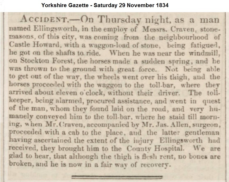
Stockton's Toll Bar
It has been speculated that Barr Lane was named after a toll bar on the turnpike. Where was Huntington Gate? this article suggests that there could have been a Bar within the 6 mile area before the lifting of restrictions on the siting of Tollgates in 1833. The accident report from 1834 suggests that one could have been in the parish.
 |
Roads and Turnpikes in Eastern Yorkshire (PDF 4.13MB) |
Pre 1760?
"New
Road is well thrown up but the exceeding wet season would only permit
'em to get a thin covering of gravel to it but if well covered will be
a fine road and give great content. This leads me to name an
inconvenience that people using Huntington Rd now lie under for they
are obliged to come by Stockton Moor and so over Monk Bridge the floods
rendering Abbey Mill Bank impassable. When your lands there were common
in winter people were able to strike into the closes at Yearsley Bridge
End and so into the horse fair and now the closes being up and the land
at White Cross and by Pepper Mill so deep that no one can come
there...happened 3 times this winter." Was about to try and enclose
Haxby. The enclosure at Strensall had been the making of that town.
There was a lot of agitation about Wigginton Road. The freemen of
Bootham Ward were liable to repair it where it crossed the Stray. They
said they were only liable to repair only a horse causey. In the end
they got a field between the Haxby and Wigginton Roads to help pay for
the repairs. Their responsibilities cont. until around 1898 when York
took over the road and the field and built Clarence Gardens on the
Field.
Foss Beck
West
of Sandburn Wood are King's Moor & Stockton Common from which
flows into Huntington a little stream the "Old Foss Beck" probably the
'Fosse between Stockton and Huntington' crossed in 1622 by a 'common
foote bridge.
In 1301 an old man lived by the Malton Road Bridge over Fosse Beck.
At the Quarter sessions in Malton on 9 January 1622 a charge was made against the inhabitants of Stockton for not making and repairing a common foote bridge over the Fosse between Stockton and Huntington.
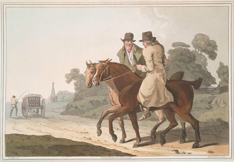
Early travel
Before coach travel it was the custom for travelers, before setting out on a long journey, to assemble in gangs, and set forth together for company and protection. The modes of conveyance were various, horses being the principal, many of the travelers riding their own, although at one time there was a system of hiring horses in stages, somewhat similar to that pursued by the coaches at a later date, whilst the course followed by some speculators was to lend the horses, which they had stationed at different stages of the journey, free of charge, conditionally that the traveller paid for the horse's keep and rested at such houses of entertainment on the road as the proprietor should nominate. For ladies who did not ride, or invalids, the old-fashioned horse litter was called into use, which was a kind of couch with a canopy, under which the rider reclined. The body was placed on two long poles, the two ends of which were fixed to the backs of the horses.
Goods were carried by packhorses, a means of transit of which the poorer class of travelers also availed themselves. Long strings of packhorse would thread their almost silent way into the quaint old streets in Indian file, with their holts and panniers laden, or with long lengths of broadcloth slung across their backs.
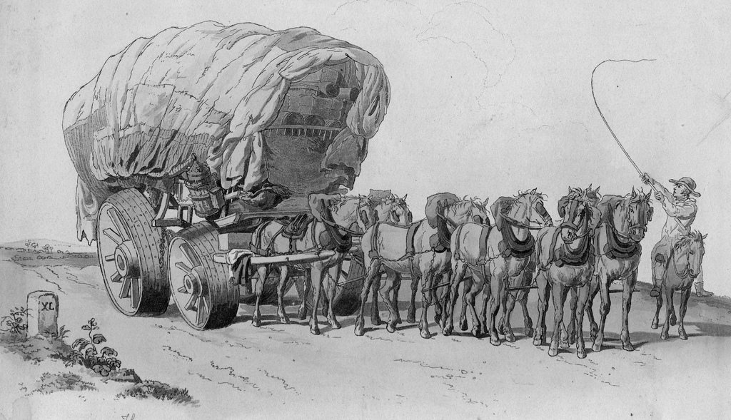
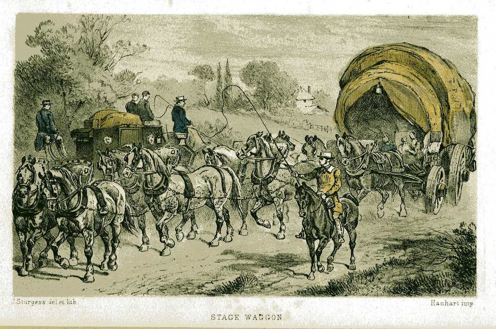
About
the year 1600, the long, lumbering, broad-wheeled waggons came into
use, and it was to these cumbersome pieces of locomotion that the name
of stage was first applied. These vehicles may have carried up to 6
tons, and travelled at 2 mph drawn by a long team of eight or ten
powerful horses. The horses have bells on above the harness, which
could be covered over. It was a legal requirement that the driver in
charge of these waggons did not ride on the wagon, too many drunken
waggoners had fallen asleep and caused accidents, so they either walked
beside the wagon or rode along on a stout sturdy pony, which was in no
way attached to the waggon, and armed with his very long whip, which he
could cleverly manipulate, he controlled his team without use of rein
or bridle.
Goods and travellers who could not afford to ride post were their chief
burdens; but it was slow, tiresome work travelling by these stage
waggons, the roads being execrable, and the great breadth of the wheels
impeding the general progress. The Government insisted on great broad
heavy wheels, with the width of the tire being specified (as What?);
their argument being that it was the narrow tires that broke up the
roads. In 1803 the old Melford stage waggons were sold - 9 inch wheeled
waggon with 8 horses harness and 6 inch wheeled waggon with 4
horses-harness
Although they were the first and earliest step in the direction of the
stage coach, or, as they were called, the flying machines, which
followed half a century later, the stage wagon and its huge pile of
baggage was still a common enough sight on the road in the coaching
days.
Even in 1714 travel could be undertaken with far greater ease on
horseback than you could by being jolted about in such an uncomfortable
contrivance, slung on huge leather braces, that was the so-called coach
of that period.
Carriers
In the pre 1700s it was common for workers to combine farming with a craft or trade. The packman or carrier was one of these trades, supplementing incomes in the slack spells before and after the hay harvest when the roads were dry and firm. As the roll of carrier was secondary the worker would be known for his main occupation and the fact he was a carrier will have been lost to history. It wasn't until 1879 that Bulmer's first recorded a carrier in Stockton, the family also had a farm and shop in the village, but by this time most villages dependant on York had local carriers who attended at least once per week.
1872
- Mathew Berry shopkeeper and carrier to York, Saturdays at 9am.
1879-97 John Richmond, farmer and carrier to York, Saturdays, 1889 also
grocer/shopkeeper
1890 - William Hewitt, farm bailiff to Mr. Smith, carrier to York (in
addition to Mr Richmond?)
1901 - 1909 - Mrs Hannah Richmond, (John's widow) carrier to York,
Saturdays 4pm., also shopkeeper
1913 - 1937 - Fred Wilson, carrier to York, Saturdays 4pm
1872 - Mr Pratt came from the Bay Horse, Monkgate, York to Stockton on Saturday.
In addition to those carriers known about there will have been others who passed through providing a similar service for their own villages.
In Pigott's Directory for 1816/17 the only carrier listed was Thomas Pilmore who left the Black Horse, Pavement, York every Tuesday for Malton.
Pigot & Co's Directory of Yorkshire for 1828-29 lists the following carriers who would have passed through the parish on their travels, and prior to 1817 they or their predecessors would have actually gone through the village.
Carriers
to York, Malton, Scarborough and Whitby from Leeds
James and Henry Hobson's Wagons from their warehouse Alfred St., Boar
Lane;
F & R Pickersgill from their warehouse Vicar Lane every evening
at seven;
Welsh's Wagons from their warehouse Bank Street;
Deacon, Harrison & Co's Wagons from their warehouse West Street;
Thomas Staples, from the Talbot Inn every Tuesday.
Carriers
to York, Pickering and Malton from Whitby
Thomas Newcombe from the Old Shipping Co's wharf every Monday and
Thursday morning
John Lawson jun. Agent and George Pearson, from the Black Bull every
Tuesday morning.
To
Scarborough, Malton and Brompton from York
Edward Cragg from Coppergate and Thomas Bonnyson from the Kings Arms
Fossgate every Tuesday and Friday.
Baines's Yorkshire 1823
Sarah Craggs ran the business at Craggs' General Waggon Warehouse, Coppergate running to Malton, Snainton, Scarborough every Tues. and Fri. at 6 in the morning and returning at 1 at noon. Goods were insured against fire. (given that the stagecoach was taking 6-7 hours there must have been two waggons in use).
T
Larkin leaves York every Tuesday and Fiday at 2 afternoon for
Scarborough and Malton when goods for Malton are delivered the same
night and Scarborough next morning.
George Pearson left every Wednesday at 2 afternoon to Malton, Thornton,
Pickering, Whitby, Staiths, Lofthouse and Castleton etc.
Both from the Waggon Warehouse, White Swan Yard, Pavement.
Tomb of the Unknown Carrier
One will live on forever in the Village Records. This poor man apparently died on the journey between his home at Malton and York. He appears to have been on his own as the curate at the time, John Blake, was unable to find out his name. He was buried in the churchyard leaving the only remaining evidence of this event, the entry in the Parish Register:-
"Buried a servant of the Malton Carrier his name unknown April 4th 1770".
One wonders if his family or the Carrier ever knew of his demise.
Poulterers?
In Baines of 1823 there are a number of Poulterers listed, some of whom were said to travel a circuit of several miles around their place of abode. One or all of the following may have attended our village.
Flaxton
- John Swan arrived Saturday 8am at White Swan Pavement. Departed
Saturday at 3pm.
Strensall - John and William Green arrivedSaturday 8am at White Swan
Pavement. Departed Saturday at 2pm. (listed as two businesses but
details exactly the same)
Strensall - Hesslewood arrived and departed on Saturday at the White
Horse Coppergate.
1800s
In 1800 it was noted that the York to Scarborough road was well maintained unlike many others in the North Riding.
Farmers and stone breakers on the road in 1813
PARLIAMENTARY ENCLOSURES IN STOCKTON 1813 - 1817
The movement towards Parliamentary Enclosure of open fields swept England during the 18th and early 19th centuries. Most affected was a broad band from Dorset, through the Midlands and East Yorkshire to North East England. The bulk of enclosure was between 1730 and 1830.
Within this belt, the prevailing system of agriculture had been an open field system with anything between two (in the earlier years) and eight or ten large fields divided into long, narrow strips (selion strips). These were allocated to members of the community, but not all were eligible. In addition, there was common land for grazing, woodland for grazing swine (pannage) and various amounts of already enclosed land. It was a subsistence system and yielded limited profits. With the rising populations of the time (Stockton 1801: 255; Stockton 1821: 450) it was proving inadequate to meet local needs.
Besides the rising population, another reason for the change lay in the developments in agricultural technology and methods during this period. The invention of the seed drill (Jethro Tull) experiments in crop rotations (especially the use of turnips) and others led to the transformation of many estates into more modem producers. A prime example was the work of Thomas Coke at Holkham in Norfolk, and. Later, of Sir Thomas Sykes at Sledmere.
Nature of the Landscape
The parish has an area of 3,200 acres. Most of the land lies between 15 and 20 metres above sea level, with the highest land to the East and North of the parish. Such slight variations in micro-relief can be of major significance with regard to drainage. The whole area is part of the broad vale of York where the underlying solid geology rarely appears at the surface. It is a product of the Pleistocene glaciation, when vast ice sheets filled the Vale some 10,000 years ago. These ice sheets retreated in a series of stages as temperatures rose and the subsequent melt waters left in Stockton two main kinds of deposits. On the one hand, there were the fluvio-glacial sands and gravels left by streams emerging from the base of the ice, and, then, where waters stagnated into lakes, there were the heavier lacustrine clays. Subsequent modifications have left a complex pattern but, broadly speaking, in Stockton the clays lie to the West and South of the village and the sands to the East and North. In general terms the line of the old village street is on the boundary between the two.
The Processes of Enclosure
After the application was approved by Act of Parliament in 1813, (The Land Enclosures Act 1813 41 George IV) at a cost of some £300, two commissioners were appointed: John Tuke, gent. of York and John Humphries, gent of Ripon. They were paid 3 guineas a day and were given extensive powers. These powers included enclosure of Common Lands (in the North of the parish) the over riding of Turberry rights (i.e. peat digging) grazing rights, the creation of new roads and the upgrading of all of the existing ones. Prior to the work being undertaken several meetings took place in York to plan the routes and the construction of new roads. At these meetings it was hoped to be able to establish who had claims and rights to certain pieces of land within the Parish. These said persons were to give in writing their respective rights, claims etc and were to describe the Lands, Grounds, Tithes and respective Messuages, Cottages. Tofts, Lands, Tenements and Hereditments,
The meetings were usually held in a Public House in the City of York i.e. 'The Red Lion' near to Monk Bar. Four such meetings were to be held before any contracts were awarded.
The First Meeting: was called to outline the plans for the enclosure of Lands in the village.
The Second Meeting: was held on Tuesday the 3rd August 1813, to establish who held certain lands etc.
The Third Meeting: was held on Wednesday the 22nd September 1813 to fix a specific date for the Perambulation of the Parish Boundaries.
The Fourth Meeting: was to hear of any objections to the plans etc, several such objections were lodged and left in the hands of the Sheriff of York.
On the 24th December contracts were awarded for the digging of 'Drains'
The commissioners were now of the opinion that the following Public Roads, Carriageways and Highways were necessary within the Parish of Stockton on the Forest.
1. The York and Malton Road. (Present A64)
One Public Road, 60 Feet in width to be called the York and Malton Road, as was staked out, beginning in Huntington and extending over Stockton Common in a North Easterly direction, to be the continuation of the Road over 'The Kings Moor' in Stockton on the Forest.
2. The Towthorpe Road.
One
other public road, 40 feet wide, now staked out, branching from the
York and Malton Road (A64) extending over Stockton Common in a westerly
direction in the direction of Towthorpe.
3 The Warthill Road (Opposite the Towthorpe
Road)
A road of a width of 40 feet now, staked out, branching from the York and Malton Road, extending over Stockton Common in an Easterly Direction to a certain gate leading immediately into Warthill
4. The Stockton and Malton Road. (Continuation of the village, Sandy Lane?)
One carriage road, 40 feet wide, now staked out beginning at the North Eastern end of Stockton and extending over 'Stockton Common' in a North Easterly direction to the 'Warthill Road'
5. The Cross Lanes Road. (Bar Lane)
A carriage road 30 feet wide, now staked out, branching off the Stockton and Malton Road at the South Eastern Corner of 'Thomas Ward's Ancient enclosed land, over Stockton Common in a Westerly direction to the York and Malton Road.
A Map signed by the commissioners on which such roads are accurately laid down and described was deposited with Thomas Preston the Sheriff's of York's own Clerk and Solicitor.
At Noon on the 10" February 1814 a further meeting was held to hear of any grievances. Prior to the meeting being held, a notice showing the proposed roads was fixed to the door of Stockton Church and also displayed in the Newspaper, 'The York Courant' of Monday 17th January 1814.
Work
On the roads did not come into immediate effect, Work tickets to
actually carry out the work were not issued until the 30th June 1814.
In 1815 additional roads both Public and Private Were planned, notice
of which appeared in the newspaper 'The York Chronicle' of 27th July
1815. The Proposed new roads were:
The Holtby Road.
A Public road 40 feet wide beginning at the road leading from York to Stockton on the Forest, extending in an Easterly direction along a certain piece of land called 'The Common Piece' to and into a certain ancient lane leading to Holtby.
The East Kingsmoor Road. (Hazelbush)
A Private road and 'Drift way' 24 feet wide branching from the York and Malton Road, extending Eastwards along the South side of a Certain Piece of Land called 'The Kings Moor' to and into a Parcel of Land called 'The Kings Moor' belonging to Benjamin Agar.
The Stockton and Huntington Foot Road.
One Pubic Foot Road or Way, 4 feet wide, beginning at the South West Corner of an ancient enclosed lane belonging to Hall Plumber Esq. Then extending Westwards over Stockton Common to the York and Malton Road.
On Wednesday 21st August 1815 the usual notices in relation to the above new roads were posted. All of the roads were built during the year 1816 and in 1817 yet another road was planned.
Wilkinsons Road.
A 'Private Road' 15 Feet wide, beginning at a certain gate on the eastern side of the Stockton and Malton Road leading to an allotment, by us and set out unto and for Benjamin Agar Esq and lease of the Prebendary of Bugthorpe. Containing two acres, which gate is placed 13 yards or thereabouts from the North-western corner of an allotment set out unto and for Thomas Ward, extending from the said gate eastwards towards the said allotment of Benjamin Agar and placed ten yards or thereabouts from the north-eastern corner of the said allotments of Thomas Ward and extending Northwards over the eastern end of the allotment adjoining thereto and containing 6 acres, 3 roods and 25 Perches ( ) belonging to Benjamin Agar as far as the gate leading to an ancient enclosed piece of land in Stockton belonging to Mr George Wilkinson, now occupied by Thomas Jebson.
The
enclosure act for Stockton on the Forest was finalized on the 1st
December 1817 in the presence of:
Benjamin Agar Esq.
The Rev Mr Noddings, curate of Stockton
Mr William Pearson
Mr William Mace
Mr James Bulmer
Mr Daniel Tuke.
The General Turnpike Act of 1822 required marker posts to be set up where a turnpike crossed a parish boundary.
From around 1830 onwards the developement of railways caused a reduction in road use for long distance goods and passenger traffic and it is believed that the York to Scarborough Turnpike Trusts' powers were confirmed by the Continuance Acts until 1865, and that they expired in 1866.
Barr Lane - alternative name for Crosslands Lane - it is said that toll gates or bars were placed across this road and Malton Road at some time in its life. The original York to Scarborough Turnpike specified that toll gates could not be fitted within 5 miles of York so this could have been after the creation of the current A64 road which by passed the village. a small fee was payable for wheel or horse traffic.
The village pond was near the blacksmith shop/Swanns Garage. In the summer wooden wheels dry out so the farmers drove their carts through the village pond to swell the wood and stop the iron tyres coming off. They also cleaned their horses feet in it as there was a lot of hoof disease about then. Since then it has undergone some transformation to become a feature pond in a front garden.
By 1850, coal gas was produced by roasting coal without oxygen to produce coke. The by-product was tar, much used for caulking the planks of ships, and was at last available in large quantities. Now a familiar sight was the little horse drawn tar boiler. Roads were sprayed with melted tar through hand-held metal pipes and granite chippings were spread over the patch. The surface was called tar macadam and then Tarmac. It is not known if this was method was used in the village at this time, or if any of the earlier road improvements by the likes of "Blind Jack" John Metcalf of Knareborough or Thomas Telford or Macadam were seen although tar trucks were in the village in the mid 1900s.
In 1872 William Lawson was the Surveyor of Highways that included the Parish of Stockton. It is not known where he was based.
The Road to Stockton
First two 1870s accounts of the route to Stockton.
Road
to Stockton in 1874
From Berwick Road, York through a common and by 2 windmills, close
right 1 mile 2 furlongs out.
A wooden bridge over the Foss 1 mile 5 furlongs out
Stockton on the Moor 1 mile 7 furlongs out
Enter the moor 2 mile 5 furlongs out
Proceeding from York, you first over a Stone-bridge cross the Foss, and at 2'7 re-cross it again over a Wooden-bridge, whence your way is generally open, which brings you at 4'6 to Stockton on the Moor a Village of 2 furlongs extent and some accommodation.
The third date unknown heading towards York.
His
horse being weak he was under the necessity of leading him part of the
road, and walked sometimes up to the boot tops in dirt especially at a
place called Lobster House. He came on to a common called Stockton Moor
about four or five miles from York where there was neither turnpike or
paved causeway at that time and he had got out of any track and was in
great difficulty.
Coaching Days
It appears that the days of coach travel had little affect on the village. As we have heard above the coming of the turnpike had made a good road to Scarborough and a number of coaches will have passed along the Main Street of the village on a near daily basis until the Enclosure Act put the main road out onto the line of the current A64. Being only six miles out from York Stockton would not have been a staging post - or would it? Click HERE for a history of coaching and its connections to Stockton.
In 1787 cartographer John Cary (1754-1835) produced a set of 46 maps as
the "New and Correct English Atlas" which was followed in 1790 by his
"Traveller''s Companion; or a Delineation of the Turnpike Roads of
England and Wales". The traveller's maps were used in a Yorkshire
Gazetteer produced in 1806 by Hargrove and Sons, Knaresborough.
Variations and updates of Cary's maps were issued up to the start of
the twentieth century.
I've not seen any of these maps but they are said to show mailcoach
roads from York to Leeds, the North and to Whitby.
Railways and Roads
At the time the rail link to Scarborough from York was opened in 1845, Scarborough had few seasonal visitors. The roads of the period were very poor making coach travel unpleasant. The rail line offered more comfort and speed for travellers to the coast which lead to Scarborough becoming the 'Queen of Watering Places' later in the century.
Mileposts (listed buildings)
|
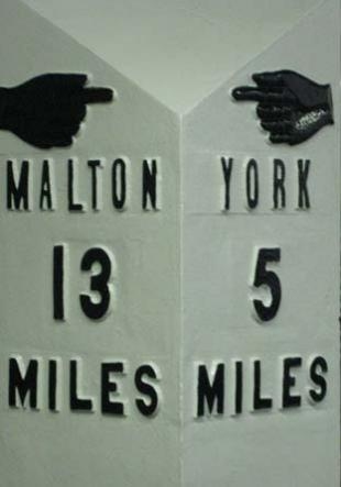
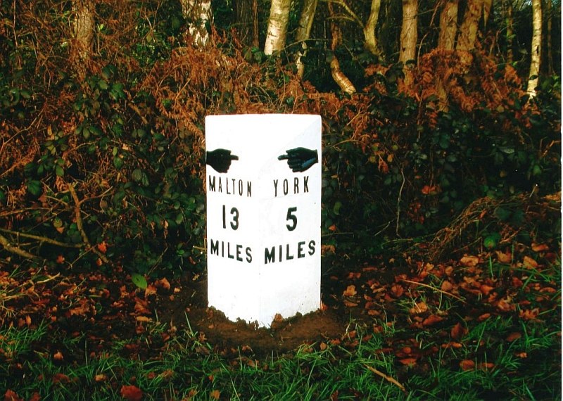
A64 NW side 500mtr south of Hermitage. Made by F Mattison and Co. of Leeming Bar, Bedale, now long gone, but was once one of the biggest employers in Leeming Bar. Its foundry operated from 1851 to 1937, and it is thought the post was put up between 1851 and 1865. Made of cast iron it is triangular in section with a sloping face. Inscription - left face : "Malton 13 miles" below pointing hand ; right face : "York 5 miles" below pointing hand. on the reverse the manufacturer's name. The
post was restored in October 2008 after it disappeared from near The
Highwayman Café around 2005. A member of the Milestone Society, a
registered charity, spotted the sign on the online auction site eBay,
and City of York Council's in-house blacksmith team restored it. The
post, which is grade II listed, has been sandblasted, welded and
repainted. It is now back in its correct place.
|
 |
A64 NW side 75mtr south of Hazlebush Cafe.
Made late 19 Century by Mattisons of Bedale in cast iron. Triangular in section with a sloping face. Inscription - left face : "Malton 12 miles" below pointing hand ; right face : "York 6 miles" below pointing hand. on the reverse the manufacturer's name.
1900s
14
March 1908 Yorkshire Gazette - by E.E.T. Special Commissioner.
"....once on the edge of the ancient Forest of Galtres. Bits of common,
great belts of wood, broad grassy borders to roads, all tell this
story. If it should be your lot, as it has been mine, to cycle
eastwards from Stockton-on-the-Forest towards the close of a fine
frosty January evening, you will not soon forget the beauty of the
woods - in the mass, a mysterious dark patch, as seen against the sky,
a miricle of delicate tracery; a broad clearing here and there in which
the resinous ends of fallen logs give colour to the landscape, or a
ploughed fiels suggests victory won by labour. There are two rows of
comfortable houses in the village. The red brick Hall at the York end
is almost hidden among fine trees and the whole suroundings are
pleasing."
The council used to have a steamroller with a tar boiler on the back and they used to park up Barr Lane for the night to get water, the road workers also slept in a caravan. After WWII came Glossops of York who had a steam lorry with a tar spreader on the back and they did the tar spraying and the steamroller rolled the stones in. Before this Tommy Musson, who lived two doors away from the church, used to have a tar boiler and could be seen patting stones down by hand. Ted Brighton used to ride on the back of the lorry when he was about nine years old and keep the fire going (1945/6).
If you went down Barr Lane, which was just a couple of wheel tracks with grass growing in between and you wanted to go over the level crossing you had to blow your horn and the gates were opened by hand by the signalman at the nearby house. Mr and Mrs Tom Hall operated the Warthill crossing gates. Warthill station was the first in England to have a single barrier at each side. They were massive.
The road through the village was very narrow and if a bus and car passed they had to really squeeze into the side of the road to do so. Mr Howland, a 'Lengthsman', looked after the road. He dug out the dykes, cleared water off the road, and kept hedges right and all that. If he needed help for bigger jobs Mr Sleights from Murton and Mr Cumberland from Huntington would come and help.
If there was a severe winter it could be very difficult to get to and from the village - there was a tractor drawn snow plough parked permanently just outside the York side of the village. 1945 to 1947 were very bad winters with 23 degrees of frost in January 1945 which was harsh enough to freeze the Ouse. In 1947 there were heavy falls of snow and strong gales which resulted in many villages being cut off. The trains were still running and carried food parcels to places like Malton where men on horseback could then deliver them to these villages. All the snow caused major flooding in York later in 1947 but had no effect on Stockton.
When they were putting a sewer through the village and they dug through the Tarmac there was a Cobbled roadway running underneath it, no Hard Core, just a rolled Tarmac road. It was just a sand road in the early days and at the far end of the village it was all wet at one side of it and they used to dig the sand out of there to maintain the village roads and others. It has been filled in now. In the 1930/40s it was known as Sandhole and children used to play in it., the Cobbles were under the Sand of the Village street hence the name 'Sandy "Lane' as it is known on the Ordnance Survey Map. The locals knew it as knew it as 'Station Road'.
A64 - 2005 plan to make it into a dual carriage way
A64 by-pass - the largest civil engineering project ever to take place near the village, it produced quite a change to the landscape with double roundabouts at Hop Grove. With the flyover on the road to York, it produced on of the best vantage points in the locality to view the surrounding landscape.
The A64 to Scarborough is itself is nightmare to travel on, especially in summer when it is grid locked both into and out of the roundabouts and for most of its passage through the parish.
In 2005 Capita Symonds under took an Environmental Impact Assessment, on behalf of the Highways Agency, on the effect that making the current A64 York to Scarborough road into a dual carriage way would have. The following is based on their comments on part of the road that runs either through or near the Parish of Stockton
The southern part of the study route runs from Hopgrove roundabout to Barton View. The route begins as dual carriageway for 550m before reverting to a single carriageway, subject to the national speed limit. The first junction heading north east is a grade 'T' type at Stockton Hall Lodge serving north lane and a small village consisting of a mixture of farm buildings and residential properties. There is a public footpath (footpath 2 on the plan) which runs for a length of 1000m between the village of Stockton-on-the Forest, crosses Forest Park golf course and meets the A64 at the Lodge (opposite north lane). There is a hospital located along the route of the footpath as it leaves Stockton heading west to join the A64. In view of this the route would carry certain level of importance to local population. Approximately 2 1/2 km further on heading north east at Hazelbush Hill is an at grade junction with Towthorpe Moor Lane serving several farm buildings and residential properties including two public houses. 1½ km further north east is another 'T' junction at Sandburn Wood.
The southern part of the study corridor is an open landscape of large fields of arable and improved grassland, with occasional blocks of plantation woodland, the majority of which are coniferous. Hedgerows are generally species-poor. In the vicinity of Stockton Common the corridor runs through an area of wind blown sand and here there are more extensive areas of both broadleaved and conifer woodland, including King's Moor Plantation, Sandburn Wood and Black Dyke Plantation, extending both sides of the existing A64. These woodlands have been planted on what was once lowland heath and nationally notable water beetles (Agabus chalconatus and A. uliginosus) have been recorded from them.
At Hopgrove the upgrading of the roundabout and the construction of an offline section of new carriageway will result in the loss of areas of species-poor semi-improved grassland,hedgerows, mature trees and a pond. The pond has potential to support great crested newt, whilst the mature trees could host bat roosts. This offline section will also result in the realignment of a section of the Huntington and Stockton Drain. This watercourse has potential to host otter, water vole and white-clawed crayfish. This could lead to loss of habitat for any of these species should they be present. The new alignment will also cross this watercourse twice, requiring culverts.
Widening the road to the west will result in the loss of a small part of Damhill Wood conifer plantation. The road crosses a stream just north of Damhill Wood, the culverting of which may result in the loss of habitat for white-clawed crayfish and water vole. The road runs offline to the east of the existing carriageway at King's Moor to avoid houses on the west side of the existing road. This results in the loss of sections of conifer and mixed plantation and a small area of semi-natural woodland at Hazelbush Wood and High Plumps Plantation. As the road moves back online a redesigned junction and overbridge results in the loss of semi-natural woodland from Sandburn Wood.
The loss of a pond at Hopgrove will have either a moderate or slight
adverse ecological impact dependant on whether great crested newts are
present or not. The surrounding grassland appears to be species-poor
and of negligible botanical interest, but would provide habitat for
newts. The realignment of the Huntington and Stockton Drain will lead
to loss of riparian habitats of lower ecological interest botanically,
but of potentially medium interest for otter, water vole and
white-clawed crayfish and, whilst efforts can be taken to try and
recreate these, it is unlikely that the resulting stream will be of
comparable ecological interest. As a result there will be a slight
adverse ecological impact on vegetation and a moderate adverse impact
on species if they are present.
·
In the area of Huntington, near to the York bypass, the road is passing
through the outermost reaches of York's suburban fringe. Views are
generally open, restricted by some domestic coniferous hedges and some
other high hedges set back from the road;
· Passing Hazelbush Farm views are extensive over the big open fields
of Stockton Common, constrained in the far distance by shelter-belt and
other plantations;
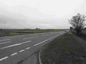
Figure 1: The view due south from the A64 near Hazelbush Farm
Beyond Hazelbush the road passes though King's Moor Plantation, with a variety of land use types in blocks. Birch woodland on the north side of the road constrains views, and the plantations on the south side dominate the scene in that direction. Hedges are gappy and low allowing long distance views to the plantations;
Property
at risk of demolition within this on-line route corridor includes:
· Fourth Milestone Cottage, Stockton-on-the-forest;
· Land take from Hazelbush Farm, Hazelbush Farm;
· High Lodge, Hazel Bush;
They also gave details of planning permissions that had been passed in the area in recent years:-
SECTION PLAN REF No; PLANNING APP NO.; SITE ADDRESS; PROPOSAL ;DATE OF DECISION; IMPACT .
63
99/01100/OTH Stockton Conversion of farm outbuildings to form five self
contained holiday cottages. 1999 Neutral
63 98/025998/FUL Stockton Conversion of farm outbuildings to form five
self contained holiday cottages. 1998 Neutral
63 01/02429/FUL Stockton Erection of single storey pitched roof holiday
cottage. 2001 Neutral
63 99/00733/FUL Stockton Erection of garden shed. 1999 Neutral
64 01/00225/OTH Stockton Underpinning works at Holiday Inn Express.
2001 Neutral
64 04/02406/FUL Stockton External alterations to doors and timber
cladding to front and side elevations. 2004 Neutral
65 99/02209/FUL Stockton Conservatory to rear. 1999 Neutral
67 99/00017/DEX Stockton Single storey side extension. 1999 Neutral
68 99/01016/FUL Stockton Conservatory to rear. 1999 Neutral
69 03/02470/DEX Stockton Single storey side extension. 2003 Slight
Adverse
69 00/01084/FUL Stockton Erection of single storey pitched roof side
extension. 2000 Neutral
69 04/02221/FUL Stockton Proposed erection of a new glasshouse to
provide an outlet for the sale of associated products for gardening and
growing stock. 2004 Neutral
70 01/00350/DOM Stockton 1 No. New dwelling of granny annex. 2001
Slight Adverse
70 01/00113/FUL Stockton Conversion and extension of existing
outbuildings to form granny flat. 2001 Slight Adverse
70 04/03858/FUL Stockton First floor pitched roof side extension. 2004
Neutral
71 01/00045/REF Stockton Erection of single storey pitched roof
extension to 2001 Neutral
71 00/00125/FUL Stockton Erection of glasshouse. 2000 Slight Beneficial
71 01/02486/FUL Stockton Erection of single storey pitched roof
extension to side. 2001 Slight Beneficial
72 00/01260/FUL Stockton Erection of detached pitched roof
garage/store. 2000 Slight Beneficial
72 00/02669/FUL Stockton Erection of detached pitched roof
garage/store. 2000 Slight Beneficial
73 02/02861/FUL Hazelbush Erection of pitched roof first floor and
two-storey side extension. 2002 Neutral
74 04/01757/FUL Hazelbush Conversion of former café to offices and
erection of single storey pitched roof side extension. 2004 Slight
Beneficial
75 02/02151/OTH Hazelbush Single storey fast food outlet. 2002 Slight
Beneficial
75 02/00805/FUL Hazelbush Erection of restaurant with associated car
parking and landscaping. 2002 Slight Beneficial
76 02/00168/OTH Stockton Toilet and shower block to caravan park. 2002
Neutral
76 01/01718/OTHDFP Stockton Conversion of outbuildings to Holiday
Cottages. 2001 Neutral
76 01/02616/FUL Stockton Formation of two holiday letting units. 2001
Neutral
76 04/03190/AGNOT Stockton Erection of agricultural building. 2004
Neutral
66 04/03131/FUL Stockton Formation of 7m high acoustic/screening bund
using imported soil/subsoil with landscaping. 2004 Neutral
General
1835
Highways Act consolidated and amended the law relating to highways in
England; forced labour for the maintenance of parish roads was
abolished, and work on parish roads to be financed by the rates and on
trust roads by tolls.
1889 Newly formed county councils took over responsibility for main
roads.
1894 Rural district councils accepted responsibility for local roads
1909 Central government began to give grants to local authorities for
road maintenance.
1920 Ministry of Transport set up.
1930 County councils accept responsibility for all roads.
1936 Trunk roads became the financial responsibility of the Ministry of
Transport.
In 1985 the main part of the village was over 200 years old. The houses along the main road don't have house numbers but individual names (many with references to agriculture, local features or mysthicism) of no particular order or logic, which can make orientation difficult if not impossible for people who are unfamiliar with the village.
Sandy Lane got its name either because it was where pre 1980s the sand storms used to cover the area, to a depth of 2 ' against some hedges, or because it was it was originally just a road of sand along side which they used to dig out sand to maintain the local roads. Villagers have commented that under the sand and Tarmac surfaces have been seen cobbled roadways. Whether these cobbles are Roman or more recentroad building is not known.
Large Abnormal Loads
Just as in the past when overloaded carts trundled through the village in modern times overloaded lorries are still a problem. R. Collett & Sons (Transport) Ltd occasional have to transport Large Abnormal Loads through the village on their way to Hull docks. Parking is suspended on the main road and bollards line the side of the road. Steel matting is put out on the grass at the turn-off to Holtby/Murton so that their vehicles can cut the corners, the only way they can get round.


Barr Lane PROTEST - On Tuesday 23rd December 2014 local residents met with Parish Councillors, Ward Councillors and York Outer MP - Julian Sturdy to protest against the proposed closure of Barr Lane at the A64 junction in February 2015. Around 50 people attended and a petition was signed.
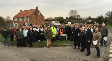
To read Julian Sturdy's full press release click here (PDF)
Bibliography
 |
The Old Coaching Days in Yorkshire by Tom Bradley - 1899 (PDF16.17MB) |